
Hybrid EO constellations tighten the noose on military concealment
Vantor plans a post-2029 hybrid EO constellation targeting 15-minute global revisit and 20 cm imagery, accelerating persistent ISR—and shrinking Europe’s concealment margin.

Key facts
- Vantor plans a post-2029 “hybrid” EO constellation combining 20 cm-class satellites with ~24 high-revisit/lower-res spacecraft, aiming for global 15-minute revisit.
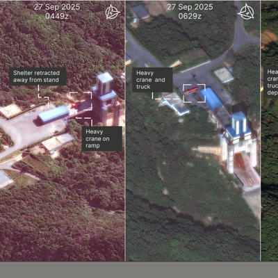
- The company says fused high-accuracy and high-revisit imagery can reveal low-signature activity (example cited: detecting a submarine surfacing) and supports damage assessment demand.
- Proliferation risk is rising: commercial imagery access is spreading, with the article citing reporting that Russia is providing Iran satellite imagery for targeting.
3 minute read
Vantor’s announced expansion plan illustrates how commercial space-imagery is converging on a persistent-surveillance model that compresses the time available to conceal, move, or regenerate combat power. The company says it will grow its current 10-satellite fleet “five-fold” with spacecraft delivering 20 cm resolution imagery, while also adding roughly two dozen high-revisit/lower-resolution satellites. When complete after 2029, Vantor claims the combined architecture will be able to image any location on Earth every 15 minutes and, critically, fuse revisit data with “exquisite” geo-accurate collection to deliver a product pitched as uniquely precise.
The competitive context is central. Planet’s move to persistent high-resolution coverage with its 30 cm Pelican satellites has already eroded the historical separation between frequent/low-resolution and exquisite/low-revisit providers. Vantor’s response is to pair higher resolution (20 cm-class, i.e., 10 cm finer than Pelican as characterised by the company) with a dense revisit layer, but the article notes advantages are likely to be temporary as Planet and others pursue similar hybrid mixes. For militaries, the practical effect is that transient signatures—brief surfacing events, rapid dispersal, short stops, and time-bounded logistics activity—are more likely to be detected, correlated, and archived.
For Europe, the implications are operational and industrial. Operationally, persistent commercial ISR will increasingly shape battle-damage assessment and targeting workflows, including in contested environments where GPS is denied and where unguided rockets or artillery require precise geolocation to be militarily effective. The article also underlines the proliferation risk: satellite imagery is no longer an exclusive US military advantage, with reporting cited that Russia is providing Iran imagery to support targeting of US forces. European forces should assume comparable commercial access pathways will be exploited against NATO and EU interests, increasing the value of deception, emissions discipline, rapid camouflage/decoy cycles, and counter-ISR planning.
Industrial and procurement-wise, Vantor frames “hybrid constellation + AI” as a way to keep data and analytics within a single ecosystem, reducing switching and potentially improving security controls for customers. European buyers weighing sovereign resilience will have to balance reliance on US commercial providers against national and European EO programmes, and consider how “targeting-grade” commercial imagery could be integrated into NATO and national C2 without creating supply-chain, policy, or classification bottlenecks. The direction of travel is clear: as revisit rates climb and AI triage matures, hiding from space becomes harder not only for peer militaries, but for everyone.
Source: Defense One